Skip to content

Mr.Senthil

  • google
  • facebook
  • instagram
  • x

Year: 2025

  • Home
  • 2025
Kaimur Hills and Maikal Hills in India | Map & Facts
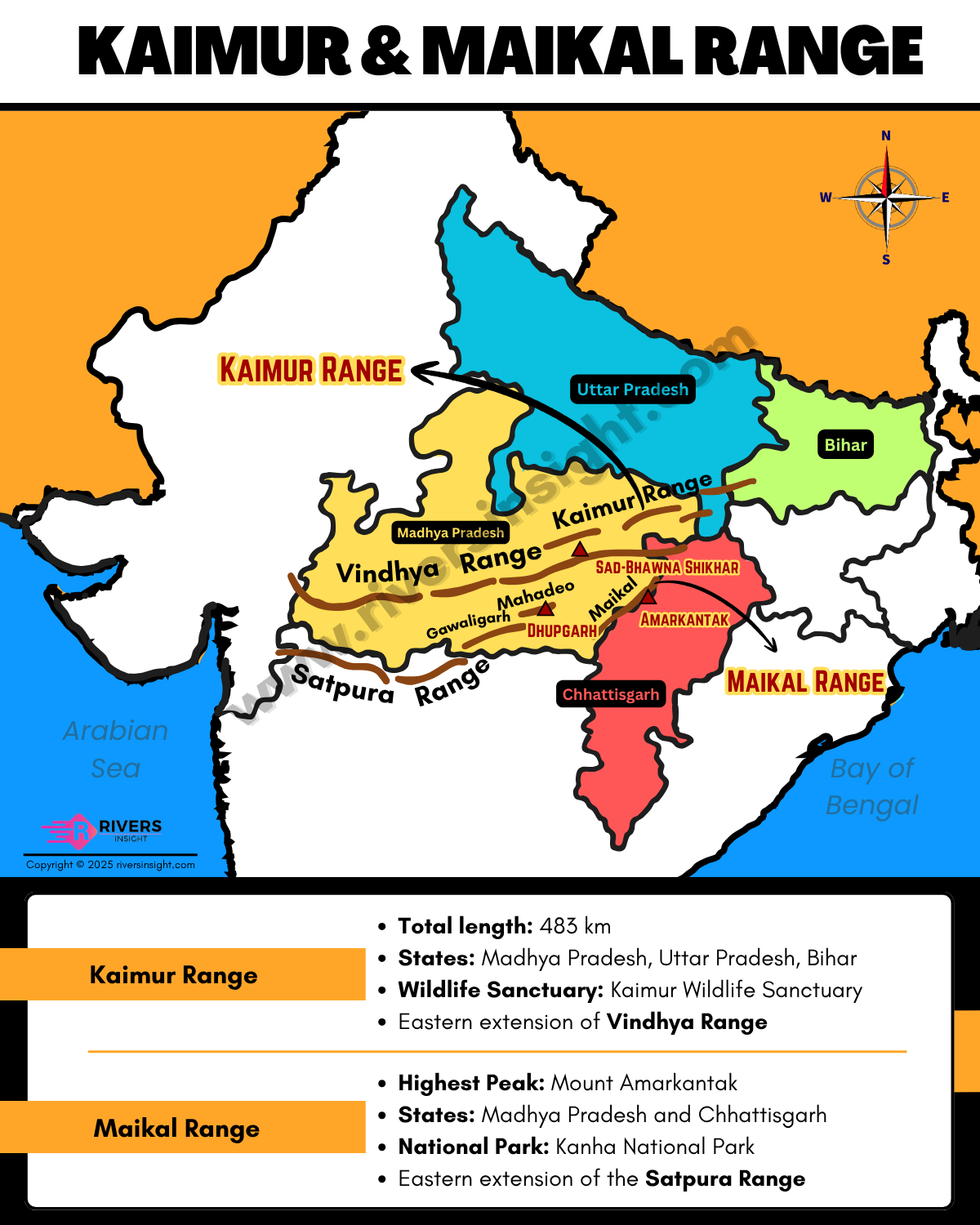
Uncategorized

Kaimur Hills and Maikal Hills in India | Map & Facts

by getlandingapage November 20, 2025November 20, 2025
Kaimur Hills and Maikal Hills are two significant hill ranges of Central India. Kaimur Hills…
Rajmahal Hills: Map & Location in Jharkhand, India
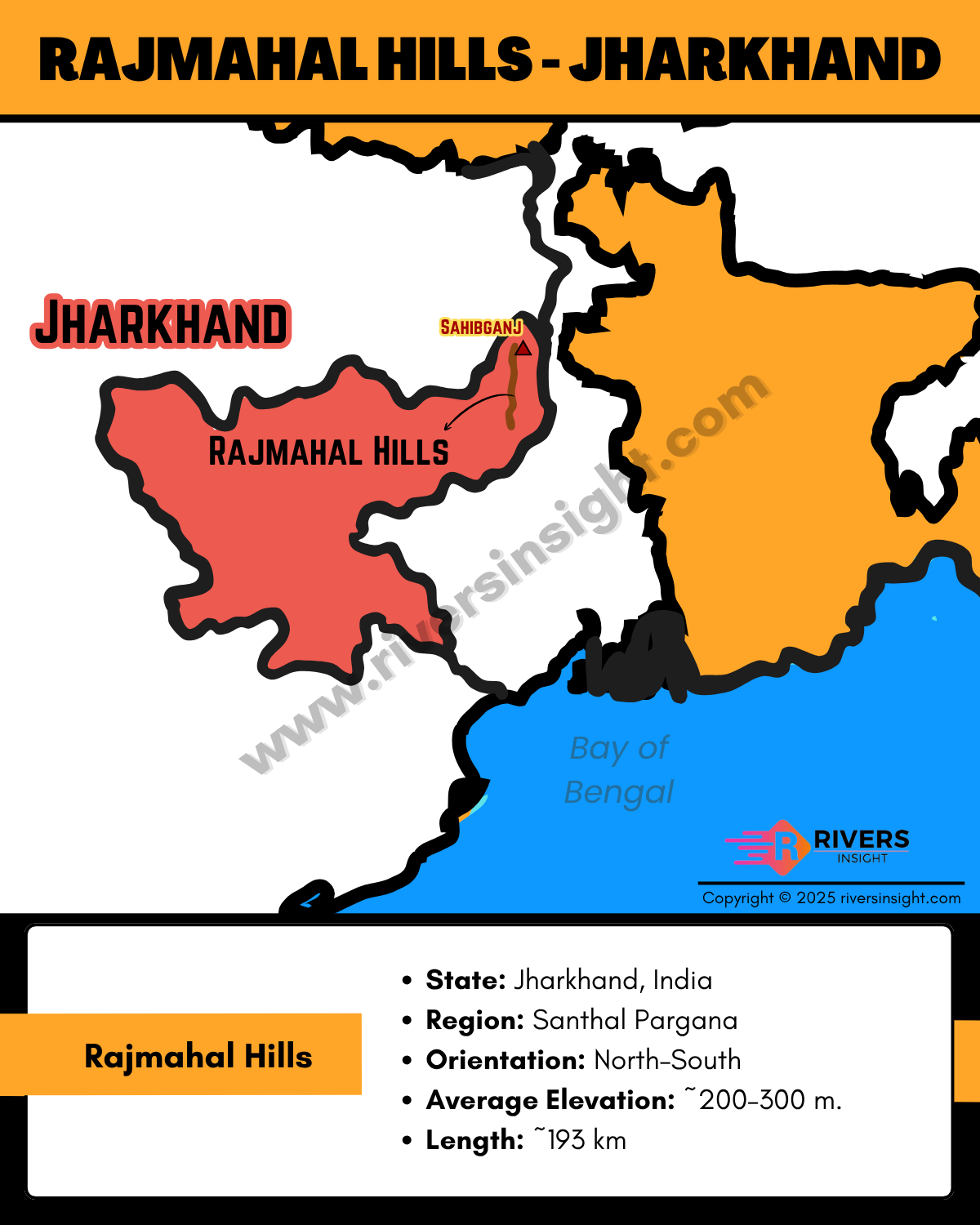
Uncategorized

Rajmahal Hills: Map & Location in Jharkhand, India

by getlandingapage November 19, 2025November 19, 2025
Rajmahal Hills are a volcanic hill range in the Santhal Pargana region of Jharkhand in…
Bhavani River: Map, Origin, Tributaries & Drainage Basin
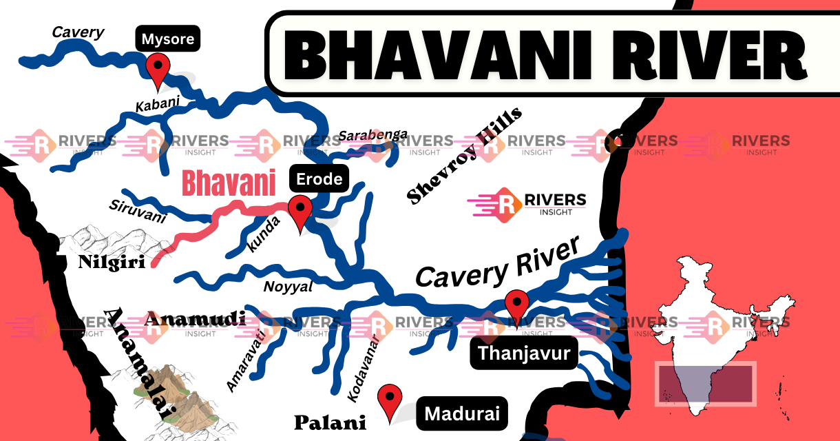
Uncategorized

Bhavani River: Map, Origin, Tributaries & Drainage Basin

by getlandingapage November 18, 2025November 18, 2025
Bhavani River is a major tributary of the Cauvery River and is the second-largest river…
Mikir, Rengma, North Cachar Hills & Barail Range of Assam [Map]
Uncategorized

Mikir, Rengma, North Cachar Hills & Barail Range of Assam [Map]

by getlandingapage November 18, 2025November 18, 2025
Mikir, Rengma, North Cachar, and Barail Hills form the transitional hill system of Assam in…
Gomti River: Origin, Map, Length, Tributaries & Dams
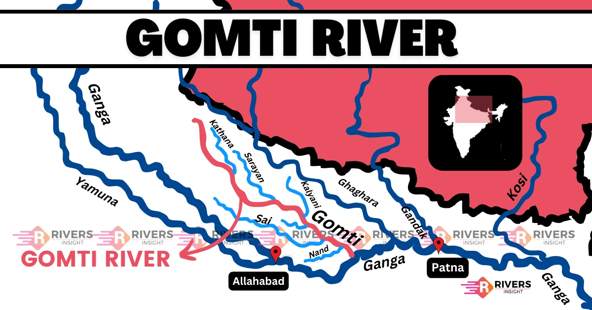
Uncategorized

Gomti River: Origin, Map, Length, Tributaries & Dams

by getlandingapage November 17, 2025
Gomti River is a major perennial river flowing entirely through Uttar Pradesh, with a total…
Mizo Hills (Lushai) – Mizoram, India
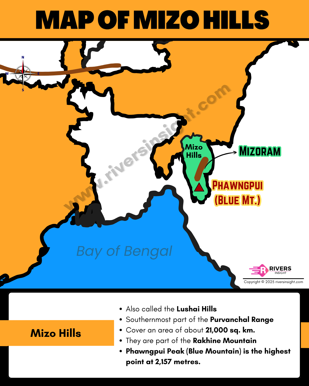
Uncategorized

Mizo Hills (Lushai) – Mizoram, India

by getlandingapage November 17, 2025November 17, 2025
Mizo Hills are also called the Lushai Hills, form the southernmost part of the Purvanchal…
Pench River: Map, Origin, Length, and Dams
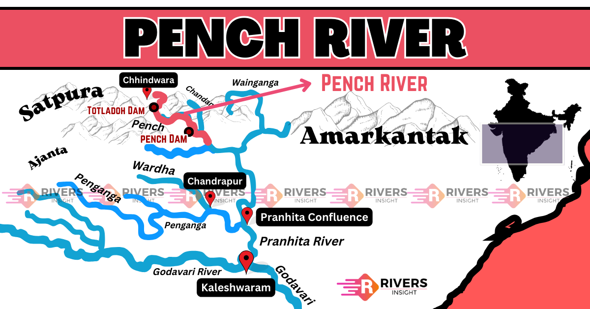
Uncategorized

Pench River: Map, Origin, Length, and Dams

by getlandingapage November 17, 2025November 17, 2025
Pench River is one of the most important rivers flowing through Madhya Pradesh and Maharashtra…
Tungabhadra River: Map, Origin, States, Tributaries & Dams
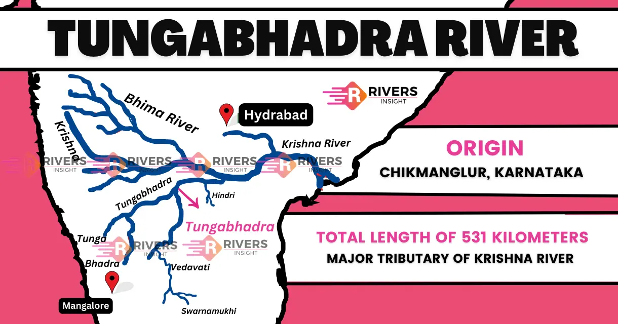
Uncategorized

Tungabhadra River: Map, Origin, States, Tributaries & Dams

by getlandingapage November 16, 2025
Tungabhadra River is an important river in southern India, flowing through Karnataka and Andhra Pradesh.…
Patkai, Naga and Manipur Hills: Map, Location & Key Features
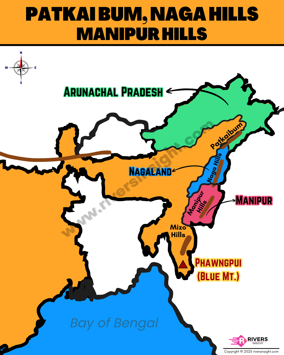
Uncategorized

Patkai, Naga and Manipur Hills: Map, Location & Key Features

by getlandingapage November 16, 2025November 16, 2025
Patkai, Naga, and Manipur Hills form the easternmost extension of the Purvanchal Hills, stretching along…
Damodar River: Origin, Map, Course, Tributaries, Dams & States
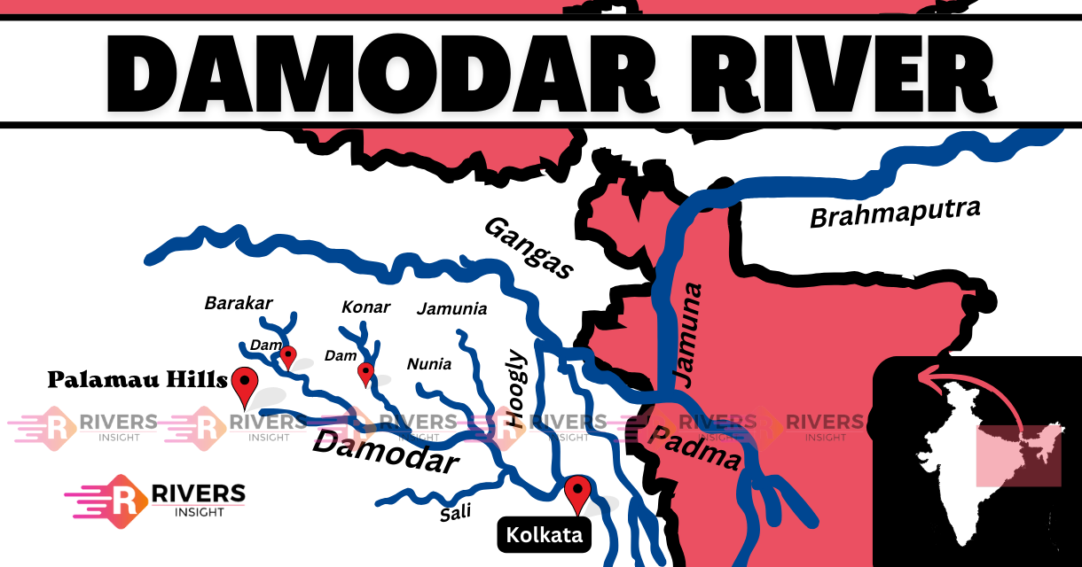
Uncategorized

Damodar River: Origin, Map, Course, Tributaries, Dams & States

by getlandingapage November 15, 2025November 15, 2025
Damodar River, often called the Sorrow of Bengal, is a major river of eastern India…

Posts pagination

1 2 … 5 Next

Recent Posts

  • Kaimur Hills and Maikal Hills in India | Map & Facts
  • Rajmahal Hills: Map & Location in Jharkhand, India
  • Bhavani River: Map, Origin, Tributaries & Drainage Basin
  • Mikir, Rengma, North Cachar Hills & Barail Range of Assam [Map]
  • Gomti River: Origin, Map, Length, Tributaries & Dams

Recent Comments

No comments to show.

Archives

  • November 2025
  • September 2025
  • August 2025
  • July 2025

Categories

  • Uncategorized

Author Info

Jerrie Doe

Jerrie Doe

CEO, Designer

Varius condimentum ultrices dignissim sapien placerats ut feugiat, nunc mollis faucibus curabitur pharetra ultricies, luctus senectus quis eleifend mus non.

Featured Posts

Son River - Map, Origin, Tributaries

Son River: Map, Origin, and Tributaries

Map of Dafla, Abor, Miri and Mishmi Hills in Arunachal Pradesh

Dafla, Abor, Miri and Mishmi Hills: Ranges of Arunachal Pradesh

Purvanchal Hills Map - Ranges of Northeastern India

Purvanchal Hills: Ranges of Northeast India on Map

Route Map of Banas River from Start to End

Banas River of Rajasthan: Map, Origin & Tributaries

Recent Posts

  • Kaimur Hills and Maikal Hills in India | Map & Facts
  • Rajmahal Hills: Map & Location in Jharkhand, India
  • Bhavani River: Map, Origin, Tributaries & Drainage Basin
  • Mikir, Rengma, North Cachar Hills & Barail Range of Assam [Map]

Initial Blog

Mauris tortor justo, porta aliquam velit non, placerat luctus ligula. Aliquam lobortis bibendum semper. Integer vitae sollicitudin ligula. Duis molestie at quam id elementum. Cras eget enim a ante vestibulum efficitur at eget massa. Fusce non varius dolor. Integer cursus elit commodo luctus dapibus.

Recent Posts

  • Kaimur Hills and Maikal Hills in India | Map & Facts
  • Rajmahal Hills: Map & Location in Jharkhand, India
  • Bhavani River: Map, Origin, Tributaries & Drainage Basin
  • Mikir, Rengma, North Cachar Hills & Barail Range of Assam [Map]

Categories

  • Uncategorized

Gallery

Copyright © 2026 Mr.Senthil Theme: Initial Blog By Artify Themes.